Frontier Brazil-Paraguay

REGION OF ITAIPU / GUAIRÁ
BRIEF HISTÓRICAL NEWS

( Version in Spanish ) ( Version in Portuguese )

Wilson R.M. Krukoski *

1) INTRODUCTION

In 1965, Paraguay raised a question on how to complete the "characterization" of the "dry line" at the arrival in the river Parana. To understand this issue, it is important, at first, to recall that the study of the limit in a stretch of international border is donne taking into account three phases of the establishment ot this border: "délimitation", "demarcation" and "characterization".

Região de Guairá / Itaipu


2) HISTORY

The délimitation of this part of the border, was established by the Treaty of 1872, which says: "... by the "álveo" of rio Paraná... From the Salto Grande of Seven Falls, follows the dividing line by the highest of Serra de Maracajú to where it ends".
The demarcation in the region ended in 1874 when, at the completion of the latest Conference, it was very well established the description of this stretch of the border: The line limit follows in the "general direction ... of 53º SE, ... with 46,3 km of distance in this direction comes to the 5ª and most important of the Seven Falls, which are formed by the meeting of the mountain with the river Paraná" (12th Ata, 8.jun.1874).
In 1927 it was signed with Paraguay a new Supplementary Treaty in order to set the limit along the river Paraguay, which had not been included in the Treaty of 1872 (It was not known to whom were the land of the right bank of the river, to Paraguay or Bolivia). The main purpose of this treaty was to establish, how the islands should be defined in this stretch of the border (from the confluense of River Apa in the river Paraguay, to the entry or desaguadouro of Bahia Negra). In that treaty, there is no reference to the "dry line", that we are dealing with.
On the ocasion of the establishment of the Joint Commission that was in charge to conduct the demarcation of this Treaty, it was signed in 1930, a Memorandum of Instructions for the operation of the Commission, which, in addiition to further defined work to be carried out, along the river Paraguay, had also stated (Art. 10º) to repair or replace landmarks on the border "dry line" donne in the demarcation of 1874; yet establesing to construct " news landmarks between existing ones, in the highlands of the border ... so that each portion of the line, could be defined by a polygonal straight, characterized by their corners and the existing marks, that should be constructed, fulfiling that any of them could, with direct sight, to see the two continguos".
Works, to improve the characterization of the border had their normal development. having started in the spring of the Arroio Estrela (at the North), followed deploying more than eight hundred marks, through, Ponta Porã and Pedro Juan Caballero, has been divided into four "dry line" Sectors.

3) DECADE OF 1960

When works arrived at the end of the Sector IV, it had the possibility to follow the "uplands" to the river Paraná by two lines: one more to the south, aiming to reach cited 5th and most important of the Seven Falls and another further North, arriving in a bathed in the curve formed by the Parana River, before falling into the groves of the Seven Falls.

Duas soluções


It was on this occasion that Paraguay raised the issue, wanting a solution more to the North, claiming that this stretch of the border had to be better demarcated by the Joint Commission, unaware that the work assigned to the Commission, was just works of caracterizatio, since the work, in this part of the border (demarcatio), had already finished int the previous century, in 1874; so the line should reach the border gorge of the River Parana, next to the "5ª and more important of Seven Falls".
Obs. See one of the best singles, correct and compleat explanation of the issue of the 1960 decade.

4) TREATY OF ITAIPU

In the decade starting in 1960 it was starting studies for hydroelectric exploitation of the region. Bearing in mind that the hydroelectric potential, depends mainly on the amount of water in the gap, the waters belonging to Pargauay were in front of the 5th fall, at the low, since no gap and therefore without potential. The sense of falls was from east to west, the Brazilian side to the wall in the side of pargauay.
This is why the insistence on Paraguayan limit, to move limit a position more to the North, ending at mountant of Seven Fall, in higher waters.
The solution, initially donne by the the Minute of Iguazu, of 1966, and after the signing Treaty of Itaipu in 1973, provided the slowdown of the question - with the sacrifice of Seven falls, as previously thought that the area under discussion would be greatly flooded. Paraguay, now had water also in the high part of the river Parana.
However, the flooding of Lake Itaipu, maximum near the barrage was minimal in the region in question (about 10%), flooding just neer the Paraguayan city of Saltos del Guairá.

Guairá flooded


Foto of Lago Itaipu
When on the occasion of the signing of the Treaty of Itaipu, there was the concern of not changing the issue of limits, even appear in the text (Art. VII) the assertion that "The facilities for the production of electric energy and auxillary works will not produce any variation in the limits between the two countries, established in the existing treaties"
So is that the solution to the deployment of the line limit in this final part of the IV Sector, should be made to reach the place where there was the Fifth Fall.

5) CURRENT SITUATION

In the years 1996 to 1998 the Commission of limits that still was working to characterize the border, managed to resume the construction of some marks - That had stopped at Mark IV/366, in the decade of 1960. So, there were built 9 more landmarks, to the Marco IV/375 even out of the bifurcation that initiate the two solutions considered (the Brazilian, more at south, and the Paraguayan more to the North). These marks are still out of "The Biological Refuge of Marcajú", which now covers the contested area
The asphalted road that comes from the Brazilian city of Novo Mundo/MS, shortly before heading out to the bridge over the River Parana, toward Guaíra/PR, has a junction that follows to the Paraguayan city of Saltos del Guairá, passing between the last mark implanted in dry line, the IV/375 mark and the Biological Refuge, administered by the Itaipu Binational.
In this region the Brazilian Federal Costum builded a post Control (now abandoned). In this stretch of road, the asphalt is stopped in both directions, due to the lack of definition of exactly where the international limit line passes, between Brazil and Paraguay.
End of Section IV (Mark IV/375)L.M.Sul
Click at the south part of the map

6) APROX. COORDINATES OF 5ª FALLING

Considering the importance of the location of the 5th Fall (mentioned in the 16th Ata from 1874 as "the most important of Seven-falls"), seeking the historiography of demarcation, geographic values, referring to Seven falls.
In the 17th Ata, there are references to various coordinates of points of the Demarcation, observed in 1874 and there we see written: "The Geographic Position of 5th Falls of the Seven-falls is latitud 24º 03´ 31.42" South; longitud 11º 06' 0.30"... the longitudes are referred to the Imperial Observatory in Rio de Janeiro". This figure correspond to the longitud 54º 18' WGr.
In 1934 determinations were made at the Paraguayan margin, in front of the 5th fall, calling the place, "Astronomy Pillar", with coordinates: -24º 03' 58,187" and -54º 17' 11,415" Also, in 1958, were held back observation on the "Astromony Pillar" and it was obtained: -24º 03' 59.3" and -54º 17' 10.5" (Values used in the 25th Ata from 1961).
Eletronorte extended its Line of Electric Transsion from Guaira/PR to Dourados/MS passing through the region. Seven of these towers (022R a 028R) were constructed in water, at the North of Itaipu Lake, so that towers 026R (-24º 04´ 07.6166" / -54º 17´ 07.1376") and 027R (-24º 03´ 54.9948" / -54º 17´ 07.4219") are exactly at the region of the 5ª Fall. If we take half distance between these towers, we have the correct point, where we can say that is the o "Theoretical Point of 5ª Fall", with coordinates -24º 04´ 01.3057" / -54º 17´ 07.2798". That we can see at the Google Earth image anexed.

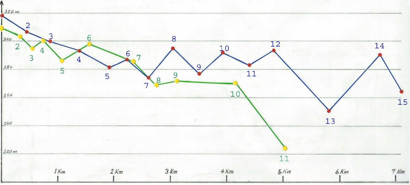
7) CONSTRUCTION OF ONE MORE MARK - IV/376

Aiming to continue the characterization of the Sector IV, we have imagined the construction of at least one more mark (it would be the IV/376), located on the other side of the road that follows to Salto del Guairá, already at the limit of The Biological Refuge, in a visible position the last mark (IV/375), approximately 250 meters.
To consider its position, without extensions that looks on topographical, the Brazilian more to the South or the paraguayan claim, at the North, we imagine an azimuth of Direct IV/375 mark of 151º, or 127º, roughly perpendicular to the alignment of the road that follows from Mundo Novo/MS for the Paraguayan city of Saltos del Guairá.

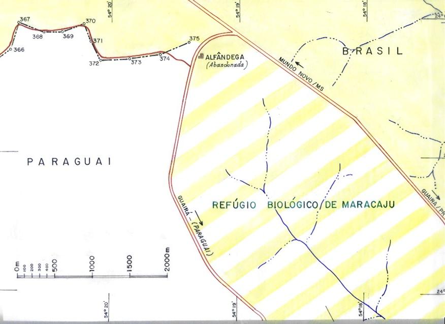
8) BIOLOGICAL RESERVE OF MARACAJU

At the moment of the solution found with the Itaipu Lake creation, it was thought that a big portion of the area in discusion would be flooded. Also in the bi-national company "Itaipu", by a resolution of its Board of Executive Directors RDE-051/84 of 27.06.1984, it was created the "Biological Refuge of Maracaju" with area of 13.56 km2, seeking to isolate the area questioned by Paraguay.
After the filling of Lake Itaipu, it was found that only one area of 1.10 km2 of the Biológical Refuge was taken by the waters (less than 10%).
Currently the reserve is administered by the Itaipu Binational, its entering is in the Paraguayan city of Saltos del Guairá and covers an area of 16.60 km2.

9) ARROUND THE RESERVE (the two solutions)
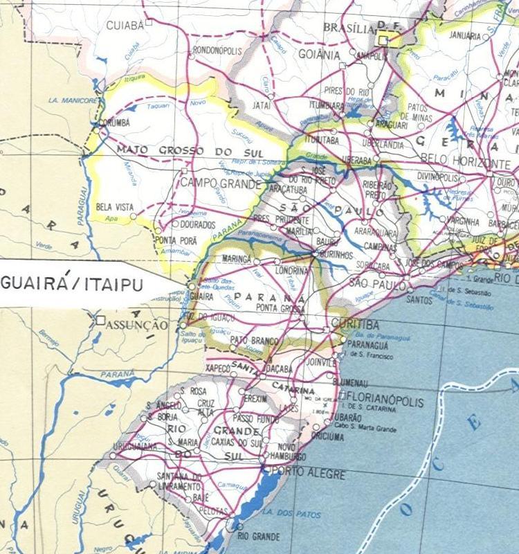
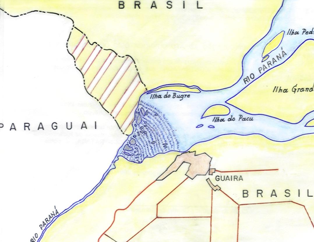
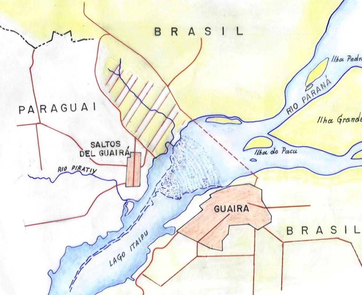
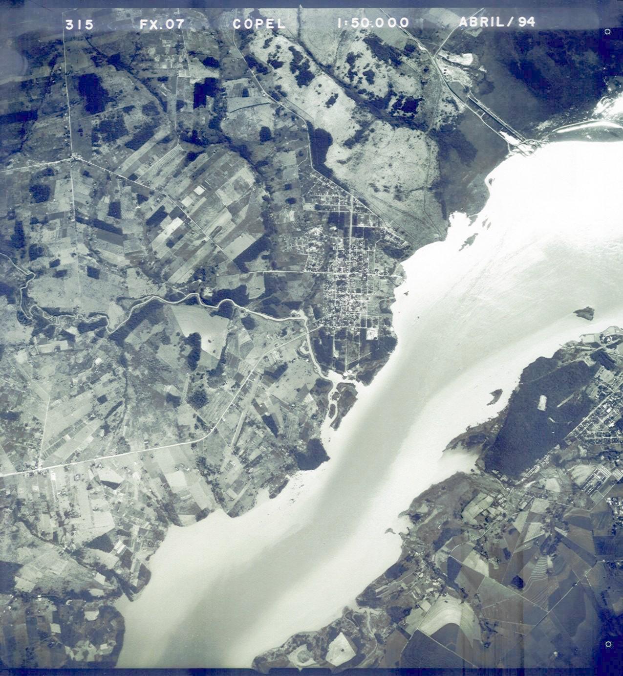
Aiming to compare both Paraguayan and Brazilian solutions, a 3 dimensional survey (horizontal/altimetric) was made along the roads following the Maracajú Biological Reserve borders, on the northern side (defended by Paraguay) and along the southern side (defended by Brazil).
It was verified that the brazilian solution, besides to follows a longer and higher road, it is heading the 5th Fall (mentioned in the 1874's 16 Act, as "the main important of the 7 Falls"), as it can be seen at the google-earth image; this condition must be obey because the Itaipú Treaty specify that because of it, no variations in the limits could be made between the two countries and this it was clearly stated in the Act and Cartography produced by the "1874 Boundary Demarcation".
Contorno do Refúgio Biológico de Maracajú Contorno
Click at the grafic in order to see the around of the Reserve by the Google-Earth

10) THE WATERS OF ITAIPU LAKE

We understand that, to study the jurisdiction of the waters of Itaipú Lake, we must consider two particularities:
1 - In the " Itaipu Treaty", it was foreseen that the works "will not produce any change in the limits between both coutries, established in the current Treaties";
2 - The current 1872 Treaty, said that, along the Paraná River, the limit follows the "alveo" of the river. Which means the waters are shared by both coutries.
When the lake was overflowed, the waters invaded Brazilian and Paraguayan lands. Therefore, they kept being both coutries´ areas.
This caused to brought the existence of three kinds of jurisdiction in the lake: BINACIONAIS waters (about the projection of the old bed), Brazilian waters and Paraguayan waters.
Than, we can say that, from one place, located in front of the "5th and most important of the Seven Falls" on: - latitude, approximately, -24º 04' and longitude -54º 17' towards south - the waters of the lake are under Brazil´s jurisdiction (at the left), Paraguayan´s (to the right), and the waters that correspond to the "water mirror" of the old bed of Paraná River, they are shared waters (or binacionals).
If any shipp leaves from east towards west, from the Brazilian edge of the lake, will be aware of entering either binacionl waters or Paraguayan´s when its eco-batímeter shows greater depth, then less ones.
At north of the said point, in the lake, waters belong to Brazil.
The other information is about the width of this space, of shared waters (correspond to the old bed of the river); it varies, from 250 to 350 meters at North, near the places of the old Seven-falls, to some 600 meters at the South, near the dam.
See views located in front of the "5th and most important of the Seven Falls 5ª Queda and near places of the damp.

* - This work represents the thought of the author, and it is the result of his research and studies on the subject.

See "The Case with Paraguay (1965-1975)", or other study on this subject on "THE QUESTION OF SERRA DO MARACAJU", or "Boudaries of Brasyl and Paraguay: from firth negociations to the demarcation and the case of Serra de Maracaju".
See Study of Guimarães Rosa, when he was Chief of the Boundary Division (MRE): "Nota 92 (mar.25.1966)"

*** Atualized at October, 8 of 2012 ***